Saturday, December 26, 2009
bio-security breach?
It has been reported that the noxious weed nutgrass has been planted on land owned by the Thames Coromandel District Council and the Department of Conservation (i.e. ratepayer and taxpayer). Some of the infested land runs along the shoreline others along side residential property.
The District Council first noticed the nutgrass in late November 2009. On the 2nd of December the District Council asked the marina company, in writing, to eradicate it and the marina company and HeB the contractors agreed to do this.
It is the Regional Council that is responsible for the bio-security of Whangamata. Until the 22nd of December the Chairperson of the Regional Pest Management Committee knew nothing of the bio-security breach, though he is in the marina company. On hearing of the situation he informed a staff member who said the first step would be to positively identify the plant.
Subsequent research from AgResearch and NIWA state that the plant is Purua grass or Bolboschoenus sp. A native plant of wetlands and coastal areas.
Maybe the plant should have been checked at the beginning by the contractors and the marina company.
Naming rights?
Tuesday, December 22, 2009
Unatural features
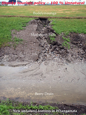
Some cultures name natural features after ancestors or as reminders of their creation story. Thus it is with the marina company. Unnatural features created by the marina and their company are named after those who helped generate these brand new unnatural characteristics of the Whangamata landscape.
· Buddymaunga – Thinks it’s a mountain but is a little hillock.
· Matherson Falls – All patched up after a recent outburst.
· Berry Drain – Debris run through it.
The marina and their company have even planted a forest on the slopes of Buddymaunga, and they have named it Don grove.
It’s a shonky tourism policy creating artificial features.
A marina suits a place where there is already something of a natural basin (including depth) and which can access the open sea without dredging.
Unforeseen problems arise otherwise.
Sunday, December 20, 2009
Soft energy attracts.
The Whangamata estuary is one of the shallowest on the east coast of New Zealand. Over 75% of its water volume leaves the estuary at low tide. Over 80% of the estuary’s area is exposed at low tide. These large inter-tidal flats attract shellfish that attract bird life including dotterel and godwits. It’s been like that for a few thousand years.
At the entrance to the Whangamata estuary is a sand delta. The flood delta is inside the entrance to the estuary and the ebb delta is outside the narrow estuary entrance. The ebb delta is known as the Whangamata Bar, one of New Zealand’s most iconic surfing spots and one of the best sandbar surfbreaks of the world. Surfing is a non-powered sport.
New technology is creating more types of non-powered craft. An example in the last 10 years are “sit on’s”. Sit ons are small rowing craft similar to an open canoe made out of extruded plastic. They are relatively cheap and have been taken up by many.
A more recent craft is the stand up surfboard. This allows the Whangamata Bar to be surfed even when it breaks less than 1 foot. Many people have also taken this up. It takes some practice to use them. Non-powered craft is where the increase in water traffic is taking place. Non-powered craft do not need marine estate.
The non-powered craft zone at Whangamata has been removed by the Councils to facilitate marine estate. If marine estate is threatened by wild life the Councils will back marine estate.
Both the District and Regional Council ran campaigns against surfing on the Bar in the New Zealand Environment Court. The District Council took it to the High Court. They continue to threaten surfing at Whangamata. The focus of Councils in the coastal marine area and coastal land area is to smooth the progress for those involved in the business of marine estate.
Number of moored craft in Whangamata on 29 November 2009.
Pole moorings – 21 boats. Swing moorings – 29 boats. Marina – 81 boats. 7 hardstand.
Sunday, December 13, 2009
Tuesday, November 17, 2009
Amendments to parking bylaw.
Thames Coromandel District Council invited submissions on district wide parking charges for cars with boat trailers parking adjacent to council boat ramps.
The initial WCA submission was posted. At the hearings on 4th November 2009 I was told by the chairperson to take the initial submission as read by Council. I then tabled and read the further submission to the bylaw.
Submission to TCDC 12 October 2009.
This submission looks at charging of carparks by the Thames Coromandel District Council (Council). More specifically trailer boat parking near boat ramps in the Council’s district area. Though the scope of the by-law is district wide, each local area has its own set of issues and character. This submission looks at the Whangamata boat trailer parking .
Two important base line perspectives that the decision makers within Council need to have awareness of :-
· There is skilane adjacent to some of the trailer boat parks.
· There is an understanding by the community of Whangamata that boat trailer charges are to be used for the purposes of upkeep of the boat trailer parks and the hard sand boat ramp in Whangamata.
· Costs for dredging at Whangamata are partially recovered through boat trailer parking fees.
· The Council recommended and contributed millions of ratepayer dollars pursuing a marina, the excavated channel of which shares the existing boat ramp area.
· Though the marina is totally on Council and Crown land it is totally a private development. It is not core infrastructure.
Recreation Reserve – Boat Trailer Carpark, Lot 9 DPS 30953. An area in the south west corner seems to recently have been elevated due to placement of marina dredgings and now cannot be used for trailer boat parking. Can Council write to WCA before the presentation date if this is the case? This land had a Gazette Notice placed on it and a CFR issued on the 13 May 2008. Can Council send those documents to WCA previous to the presentation date?
Pt Sec 13 BLK XVI Tairua SD Council owned land extending off the western end of Beach Road. Council brought this land for a community reserve and trailer boat parking. In the 1970’s a problem surrounding lack of trailer boat parking and a future need for more community reserve space was identified by the Whangamata Community Board. Somehow the purpose of purchase morphed into providing land for a private marina development. The marina development, possibly speculative in nature, has impacted negatively on the amount of trailer boat parking. This has eroded the value of community assets, these being the boat ramp and its ancillary parking; organised around a scale required for trailer boat parking.
Council legal and planning consultants and Council planning staff involved in the marina consents did not advise the Council these losses would result from the development.
The submitter requests -
· The information asked for earlier in this submission.
· That the yearly charge for trailer boat parking of around $65 pre year is retained and spent on retention and upkeep of exiting trailer boat carparks, the sand based boat ramp and the skilane reserves at Whangamata.
· That the Council stops paying a contribution towards boat ramp channel maintenance to the marina company. The marina company has had seed money contributed by the Council and it is impacting negatively on trailer boat parking and has lessened the degree of road safety. The lessening of the degree of road safety has been caused by boat ramp users now having to use meridian strips, on the beach, on inter-tidal flats, road side parking deep into the surrounding residential area of the boat ramp. This is an effect of the marina development yet to be explained to the community.
Further Submissions to Parking Amendment 4 November 2009 to the Thames Coromandel District Council from the Whangamata Camping Association.
The problem of overflow parking was avoided at Labour Weekend because Council land, part of the Extra High Density Housing Area, was opened up for overflow trailer boat parking for those using the Whangamata boat ramp. The use it was brought for by the Council.
The solution to the overflow parking requirements for the Whangamata boatramp is to change the zoning from Extra High Density Housing to a zoning allowing parking. This will be at a cost to the Council and the write down on the land value will be significant.
Unfortunately for the ratepayer the Legal and Planning team for the Council during the marina consents never told the ratepayer or the Court of this possible loss of value. As they never told the ratepayer and Court that the largest population and habitat of indigenous coastal reptiles lived on this Council owned land. The loss of this bio diversity is more significant that the housing write down
The submitter requests -
· That the yearly charge for trailer boat parking of around $65 pre year is retained and spent on retention and upkeep of exiting trailer boat carparks, the sand based boat ramp and the skilane reserves at Whangamata.
· The trailer boat parking fee in Whangamata is not used by the Council to hide a “marina tax” to sponsor private investments and speculation.
Thankyou.
Whangamata Camping Association.
Tuesday, November 10, 2009
Mud magnet.
Mud sticks. Once accumulated it’s very hard to shift.
Sand rolls. In the wind, in storms. In water with tidal and current movements.
From the 11 to the 13th of October a group of Whangamata Camping Association (WCA) members walked and examined, around low tide, the recently excavated channel from the dugout marina basin down to the boat ramp. This part of the channel has never been dredged or altered previously.
The dredging and excavation is from a natural depth of .25 to .5 m to an artificial depth of 2m (at low tide). Rock walls and a weir structure have been placed in parts of the channel at the entrance to the excavated basin.
The most noticeable thing at such an early stage is the mud. The numerous black rock structures, only in the water months, are already deeply stained. Thick mud 5 to 10 cm thick has accumulated on the low tide flats behind the rock walls. All the marina structures are mud stained including the concrete pontoons.
The recently built weir has mud building on its surface. The structure is nearly always in moving water.
Where the rock wall ends a micro channel has formed. It runs from the low tide mark to a point 3 to 4 meters out from the rock wall and then runs (roughly) parallel to the dredged channel and joins up with (what was) a dead end channel opposite the boatramp (click on photos to enlarge.) The dead end channel opposite the boat ramp has been there for some time. The micro channel is new and came after completion of the rock wall around September 2009.
The most noticeable change is the increase in heights of the sediment banks on the western side of the causeway bridge. The increase in height has meant the channel has now carved faces into the sediment banks along its low tide meander, something that never happened previously.
The damming effect caused by the cauceway (built in 1974), is well documented. It has caused rapid infilling up stream with associated encroachment of flora. It was a known ecological disaster. Has this infilling now been accelerated?
While walking around the intertidal flats, WCA members were told by HeB workers on the site that crayfish had started living in the rock walls, and the marina is going to have problems with the channel and basin filling in.
Sunday, November 8, 2009
Return of the godwits
Whangamata’s godwits are back home for summer. The usual pattern of return is a small (strong) group returning first. Within a week that small group doubles in numbers. A few weeks latter the rest return. (Click on photos to enlarge).
These photos are taken at the eastern (town) end of the Whangamata estuary where the godwits roost on the high tide. 80% of the harbour area is dry at low tide and around those times the flock forage over the large intertidal flats.
The photo of 7th November 2009 shows a piling barge moored in the background. The barge has spent a few weeks in Whangamata checking swing moorings and replacing poles. Though moored craft owners are a very small minority amongst boat users, let alone harbour users, they seem to own the Waikato Regional Councils budget and agenda for all of the Whangamata coastal marine area.
The Councils don’t understand songs of the godwit, bio diversity, cultural history or nuance like wave quality. Their attitude is they are not going to waste time or money on such things. For the Councils marine brokerage has priority as the baseline for Planning strategy in Whangamata.
The Waikato Regional Council has placed a mangrove tax on the ratepayers of Whangamata. Every one needs to be alert that the Councils do not place a “marina tax” on Whangamata. Where by the Councils disguise revenue gathering or expenditure to subsidises the investment and speculation platform of the marina company. The main techniques will be non notified consents and public excluded minutes on what are corporately owned public lands, foreshore and seabed.
A few signs around the Beach Road reserves would help protect the godwits while roosting. The Councils have refused expenditure for this.
Number of moored craft in Whangamata on 18 October 2009.
Pole moorings – 51 boats. Swing moorings – 50 boats. Slipway – 3 boats.
Friday, October 16, 2009
Sand mining forever at Whangamata?
The natural channel of the Moana anu anu has been deepened to allow boat access to an excavated marina basin. How much material has been mined out of the Moana anu anu channel bed and its delta? This has not been explained by the Waikato Regional Council Coastal Programme or the Department of Conservation, the two authorities responsible for activities in the coastal marine area (ironically on behalf of all citizens).
In the applications for resource consents for the private marina there was never a request to use the public Whangamata boat ramp for sand mining works. Over twenty days in the Environment Court and two different Council legal and planning teams never assessed that the boat ramp was to be used in this way.
Recently the Minister of Conservation and the Waikato Regional Council gave the marina company permission for five more berth spaces. The deal was done through the back door.
Yet no space has been given over to obvious periodic sand mining works required to keep the excavated basin connected to the open sea. What of the muddy crap that will becoming from the bottom of the marina basin, is that to go out on to land via the boat ramp also? The marina company were supposed to build a boat ramp within their own (leased) area. This could then be used for transporting the large amounts of seabed required to keep the marina open. A subsequent backdoor deal with Councils allowed them to delete that boat ramp.
The trouble with back door deals is they do not protect people’s use of the coast and commonly held assets, in this case the boat ramp.
Wednesday, September 23, 2009
Sand Mining at Whangamata
The photos in this post were taken form the same spot but different angles at the Whangamata boat ramp. The photo top shows the sand mining as a result of the Whangamata marina construction consents. The Public were never notified or told this was going to happen at the boat ramp. The sand is being excavated because the 1 kilometre channel connecting the excavated marina basin is naturally .25m - .5m deep at low tide. To operate the channel will require a depth of 1.7m at low tide.
The photo below shows in the right-hand foreground, the Whangamata boat ramp. It is river hardened sand and many people launch their boats in bare feet. Up to seven boats can be launched simultaneously. It is a safe boat ramp to use.
The rest of the channel can be seen meandering to the left. The line of poles mark the right hand side of the channel. It is this part of the channel where the piled sand has been mined.
What is clear is that months per year of sand mining will be required to keep the channel open, and that a dedicated spot on the foreshore and on land will be required to stack it. Yet the authorities have not told us yet where this will take place and who pays.
Friday, September 4, 2009
Perpetual un-notified consents?
The post of the 31 July 2009 was a submission by the Whangamata Camping Association to an application to the Waikato Regional Council (WRC). This application was for a coastal permit for exclusive occupation of foreshore at Whangamata. There are two other regulating authorities that also had a say in the application. These are the Thames Coromandel District Council (TCDC) who administer the boatramp, where the exclusive occupation is taking place, and the Department of Conservation who are seen as the owners of the foreshore and seabed on behalf of all New Zealanders.
The consent was granted to the private developers by WRC with input from TCDC and DoC around the date of 7 August 2009
The photograph below shows the sand bulwark under construction and the photograph above shows the structure with the machinery laying idle. When this machinery and structure is in use, it resembles a marine quarrying operation. The sand wharf structure has become larger since these photographs were taken.
The planners and lawyers who progressed the district and regional councils case through the courts and into Parliament, never forewarned that the boatramp would be given over to the private developers or that a marine quarrying operation would begin in a residential area.
The compliance officers at the District and Regional councils never knew this was coming until it was on their desk. Ten months into construction!
Part of the purpose of planners and lawyers who consult or work for Councils and Ministries is that they assess the effects of an application on behalf of those that pay them. They require some skills in understanding how something in a sensitive and controversial setting (the Whangamata estuary) will unfold.
The WRC, TCDC, and DoC are now saying that this sand and sheet steel bulwark and marine quarrying operation will be temporary. Are these authorities in control of the situation? How will the required dredging operations take place in the future?
Wednesday, August 19, 2009
Ch-ch-changes
The post of 31st July 2009 was a submission to Waikato Regional Council (WRC) by the Whangamata Camping Association (WCA) to an application by HeB Construction for a Coastal Permit to occupy the Coastal Marine Area (foreshore). Specifically the area to be occupied is the western portion of the Whangamata boat ramp. Occupation of the foreshore is requested for the temporary dumping of dredgings and the building of a temporary structure. The dredgings will come from the digging a 1kilometer channel, to a man made depth. The channel is required to connect a constructed marina basin to the open sea.
That an application to occupy the coastal marine area was applied for 10 months into the construction period is surprising. The area to be exclusively occupied is a long-standing amenity, it is safe, and it is often in use. It is seen as a Public asset.
The planners and lawyers who progressed the district and regional councils case through the courts and into Parliament, have huge power over people and their environment. They are hired and paid highly from rates and taxes to bring a studied rationale to the management of the coastal environment and river management. They failed to mention that the boatramp and the surrounding area would become a construction zone. They hid or didn’t understand what was going to happen. This problem is recurring, the difference between evidence to the court and actual reality.
Since the submission was sent WRC has allowed HeB Construction the coastal permit to occupy. The photographs top and bottom shows the beginnings of the works. A pile of dredgings, left to the tides and rain for a week. 30% of the piled sediment has returned probably to the hole it came from.
Friday, July 31, 2009
Submission to Waikato Regional Council
EWDOCS-#1493845. Application for Coastal Permit to occupy the Coastal Marine Area at the Whangamata Boat Ramp.
The Applicant is HeB Construction
The WCA thanks Waikato Regional Council for the chance to submit to this unnotifed consent application.
The WCA does not believe the Whangamata marina is core infrastructure. The asset is held privately on Public land. WCA believe there is no public good in these applications.
The consent application does not address road and marine traffic management. No understanding of existing use of the boat ramp or the access channel is contained in the application. The safety effects on vehicles with boats on trailers, the effects on safety of boats in the access channel are not clearly assessed.
The application is unusual in that it is from a contractor during a job. A former failure of methodology is mentioned as the reason for the consent application. No understanding is given within the application of factors leading to that failure.
The application puts forward three different options. They are referred to as Appendix 1, Appendix 2, and Appendix 3. WCA will refer to all three options but understand from members of the Whangamata Trailer Boat Association, that only the option of Appendix 1 was explained to them. WCA assume this is the only option being discussed. Appendix 1 was not referenced in the first 7 parts of the application, only Appendix 2 and 3 were.
4. Details of the Activities. The description gives little understanding of methodology and effects in a busy area. There has been a recent accumulation of mud at the base of the recently stock piled dredging. Users of the boat ramp, especially at low tide, say mud is getting in their boats and cars where previously it was only sand.
5. Description of proposed activity. The details give little understanding of methodology and effects in a busy area. The application states this method is the most economic. For the contractor not the community. The best option is the digger on the barge taking back the dredging to the marina basin and placing it on land leased to the marina society from the Council. Public space should remain for public use.
7. Consultation. The Councils should test public concern of these applications by requesting interest via advertisement’s in the local papers.
Appendix 1 The option of Appendix 1 was operable for a short period recently. WCA believe that these operations exasperated the mud at the boatramp. The trucking is not compatible with the safe operation of an open boat ramp. The use of a long armed digger working form the channel sides is not compatible for the safety of boat traffic.
Appendix 2. This option brings more of the marina dredging operations, including de watering and holding areas, off their leased property on to public space. There is no understanding of traffic movements or the times of traffic movements.
Appendix 3. WCA are concerned that this larger structure is the precedent that will be required by the marina society for the almost constant dredging required in trying to provide access to the marina basin. This option would require a full public process and an Assessment of Environmental Effects far grater than what is being currently accepted by the Council.
Decisions Requested:
· WCA requests that the Council raise their expectations of what is an acceptable standard for an Application to occupy coastal space
· WCA believes that there are not enough details to assess vehicle and navigation safety for existing users.
· The barge and digger option, but with an extra dogman on the barge, taking back dredgings to the marina basin and using the marina societies leased land to pile and de-water dredgings, is the safest option and the only one in line with consents already held by the marina society.
· The WCA also request that the Councils demonstrate that future dredging of the channel to maintain access to the marina basin will not entail transference of costs to the ratepayer and a loss of even more public space to the taxpayer.
Thankyou. Facilitator: Grant McIntosh. 31 July 2009
Saturday, July 18, 2009
On the 16 July 2009 I was on the causeway bridge taking photographs of the first high tide to go through the partially constructed marina. Until then a sand cofferdam had surrounded the construction area. The sand had been pushed flat by diggers.
It seems it was also used as an opportunity to flush out some pollution into the estuary.
While watching one of the local fish and chip shop owners walked past and stood to watch as well. He asked “Does that marina basin have no back wall?” The design of the marina is such that the tide goes in the entrance and then out over the top at the back of the basin (visa versa when the tide is goes out). Pointing to the basin he said “I’ve got one of those at work, its called a grease trap.”
Sunday, July 12, 2009
12 July 2009. All photos enlarge when clicked
The digger above is shifting around marine sediment from the seabed of the Moana anu anu channel of the Whangamata estuary. The sediment (mainly sand and biological sea life) has to be dug out otherwise the recently excavated marina basin will not have boat access to the open sea.
The digging out of seabed to create a channel and then placing that sediment on land is rarely recommended in coastal process text books, journals etc over the last 25 years. Yet (about) 12 environmental managers being; lawyers, judges, planners, scientists, recommended it and it is now being done.
Some of those opposing this practise were
- Iwi / hapu, (effects on traditional shell fish beds and access to kaimoana). Breach of Tikanga.
- surfers (it will increase water velocity thus changing natural channel routes; the area is one of the sand reservoirs of the nearby Whangamata Bar).
The coastal land currently used to dry out the marine sediment is owned by the Department of Conservation (aprox 2.4 ha) and the Thames Coromandel District Council (TCDC) (aprox 2.5 ha). The TCDC purchased the land in 1985. The money came from rates. The TCDC will not explain which of the Council budget’s these funds came from. While in private hands (1941 to 1985) the Council had it zoned “proposed recreational reserve”. A recent submission of the Whangamata Trailer Boat Association, to the TCDC, 2009-2019 - 10 year plan, gave evidence that the land was purchased for overflow parking for the near-by public boat ramp and for a Public reserve.
Currently the TCDC are charging $100,000 (includes GST) per annum land rental to the marina developers. What rentals the Department of Conservation are charging for the Crown land is a secret between DoC and the marina developers.
Occupation charges to those trading in berths, of the marina basin area by Waikato Regional Council, is also secret.
Monday, July 6, 2009
Where the blowout took place was quite defined. It was adjacent to the entrance of the incomplete marina. This is an area of complex engineering and design. It includes a weir (or drop structure). It’s an area where water rises out of the seabed.
According to the Crown (via the Waikato Regional Council) this is saltwater. The video at the top (click to start) is of a water vent now covered by the partially constructed weir. The video at the bottom is of a water vent near the base of the permanent rock entrance. There is a long documented history of freshwater surfacing in this area. If these vents were to be freshwater it would create issues over accumulative time along with the pressure of tide and floods.
Wednesday, July 1, 2009
At 7.30 am on the 1st of July 2009 I walked out along the construction bund, of the partially built Whangamata marina, to the area where the bund had recently (Tuesday 29 June 2009) blown-out. I assumed that the breaking of the bund, the inundation of water, the pushing of sand back into the excavated basin, the litter of construction materials, the sinking of port a loos, pumps and other equipment was not intended by the developers, the contractors and the Councils over looking this project. Some of the construction materials left the construction zone and floated out into the estuary.
What was it that caused the blow-out?
· was it the construction,
· the force of the tides
· the flow of the river,
· the amount of storm water entering inside the basin
· fresh water coming up underneath the bund
· systematic error somewhere in the developer / contractor / council paradigm
· a combination of the above or something else all together.
In the coming weeks an expectation is that an official report will explain what happened.
Exactly one year ago at 7.30 am I visited some of my friends who had gone camping on a Crown road and Public land by the inner waters of Whangamata. Today at 7.30 I went to the same place but it was now a vast construction site that extends from the land into coastal marine area. The area is unrecognisable from what it was a year ago.
The reason for the camp was to protest the building of a marina on this site. The idea for a marina was an old one and had been argued in the abstract since the late 1970’s. It started in 1996 when the New Zealand Government processed an application to develop a marina from the Whangamata Marina Society. From this point onwards the decision whether to have a marina or not has gone through the Community, District and Regional hearings, the Environment Court, the High Court, Parliament and the Ministries of the Environment and the Ministry of Conservation. During this process an estimated $20 million dollars was spent by the Crown’s (NZ Government) environmental management systems. This $20 million was used by the Crown to employ politicians and educated people in the areas of planning, science, engineering, and the law. The money for these people came from taxation.
In December 2006 the Minister of Environment granted permission for the development of a marina at Whangamata. The developers have said they will spend up to $20 million dollars. The developers are operating under the Friendly Societies Act. Where the money is coming from and how it moves is vague.
The construction of the marina began on the 1st of October 2008. The abstract arguments have now finished and the actual is taking place. The Crowns environmental management systems and the developer’s submissions to the Crown would from now on be tested in the real world.
The question is still to be determined. Those campers; were they there to bear witness. to finish something or to start something or all of these things?